Application
We cooperate with local developers to provide industrial solutions for customers.
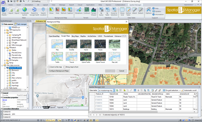
'Spatial Manager for GstarCAD' is a powerful GstarCAD plug-in designed for GstarCAD users who need to import, export, manage and enhance spatial data in a simple, fast and inexpensive way, which includes many possibilities not seen so far in GstarCAD. It comes in a lightweight application that runs inside GstarCAD and, briefly, the following are the features you can find in 'Spatial Manager for GstarCAD':
? Import into GstarCAD from Google Earth (KML or KMZ), OpenStreetMap (OSM or PBF), Shapefiles (SHP), GPS, Points (many formats), Excel, Access, ESRI ArcInfo?, MapInfo, GML (GML or GZ), GeoPackage, PostGIS, SQL Server, SQLite, and many more geospatial sources
? Export from GstarCAD to Google Earth (KML or KMZ), Shapefiles (SHP), GML, Points (many formats), MapInfo, PostGIS, SQL Server, SQLite, and many more geospatial targets
? Transformation of coordinates when needed in any process
? Drawings Coordinate System transformation
? Backgrounds Maps, powerful and easy to use
? Search Locations
? Terrain functions including 3D points from elevation services, DTM meshes, contours, etc.
? Publishing to Google Earth
? Alphanumeric data tables as GstarCAD Extended Entity Data (EED). Manage data tables and fields. Data viewer and editor included
? Save Tasks to replay the import processes so many times as desired
? Interface simple, intuitive and productive
User Guide
http://wiki.spatialmanager.com/index.php/Spatial_Manager%E2%84%A2_for_GstarCAD
Youtube:
https://youtu.be/Oh4fCELK2pI